
Tags
In the wake of the Lapérouse expedition at Tutuila (Samoa) – Bernard Jimenez
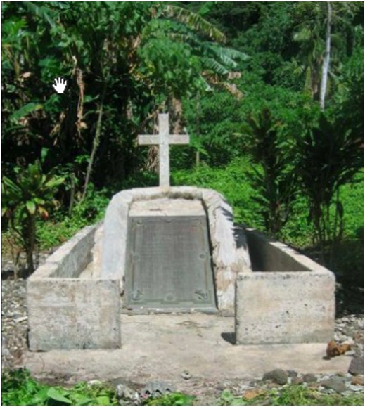
(left: Monument to Laperouse expedition members massacred. Link to lecture on restoration of monument - Johnson & Slavid - “Case study of the restoration of the Monument at Massacre Bay, A’asu, Tutila, American Samoa).
Bernard and Françoise Jimenez have recently set out for Hawai’i and Samoa in the wake of Lapérouse. This first report retraces their discovery of the places where the expedition made landfall on the island of Tutuila (Samoa) and the drama which took place there.
The island of Tutuila, that Lapérouse named Maouna[1], is today part of American Samoa. It is here, in the bays of Fagas and then A’asu, that first contacts ashore took place – at first very friendly then dramatic – between Europeans and inhabitants of the Navigator Islands, discovered by the Dutchman Jacob Roggeveen in 1722 and so named by Louis-Antoine de Bougainville in May 1768.
Fagasa Bay (Anse de l’aiguade)
Although there is a large, well-protected bay to the south side, that of Pago Pago, Lapérouse made landfall on the north side of the island on 9 December 1787, moreover making a scathing attack on Bougainville for the lack of precision of his charts. Lapérouse wrote in his log: “It would have been desirable that these particular maps were drawn up with greater care and on a larger scale”[2]. The two frigates anchored first in sight of Fagasa Bay and many exchanges took place with the islanders: “more than 500 pigs, chickens, pigeons, immense quantities of fruit […] and two dogs which were found to be very good”(2). Then cutters and ship’s boats landed under escort at the far end of the bay to fill the ships’ casks with fresh water. Today, the two streams, the Le’ele and the Fagasli, still flow at the same spot, and the small village, one of the most charming on the island, lives peacefully at the foot of the surrounding mountains carpeted with damp tropical forest. The large church and the houses close to the bay, which were destroyed first by Hurricane Heta in 2004, and then by the terrible tsunami which struck Samoa on the 29th September 2009, have been rebuilt and painted in bright colours. Arriving by car along the small road which climbs and then tumbles down the green wall separating the south coast from the north coast, we met the few men present and asked permission to enter the village. The welcome was always very warm and always excited the same astonishment: why come to Fagasa from so far away?
According to Lapérouse, everything went off well at Fagasa “although he [found] these islanders were too unruly to send ashore cutters and boats which could only be backed up by gunfire from the ships” (2). But, as one knows, he finally let himself be convinced by de Langle and, on 11th December, a new watering point was planned in A’asu bay, five miles to the west.
A’asu Bay (Anse du massacre)
We went there twice. The first time was from the village of A’asufou (the new A’asu) perched on the rocky ridge which overlooks this well protected little bay.
The path is scarcely marked in the very dense forest which lets light filter through in spots with difficulty. It is slippery and becomes a torrent as soon as there is a shower…which however is welcome as it cools the atmosphere.
After more than two hours of a steep descent – that will have to be climbed later – we came upon a hut set back from the beach. At Pago Pago, we were told of a couple who had come back to live at A’asu; they were there and welcomed us with signs and tried to hold back their dogs. Maria was born at A’asu (today A’sutoui, the former A’asu) then, when the village was moved to the ridge following a hurricane which swept everything away, she had to leave this little paradise but swore to return and live there one day. And she returned two years ago with her husband, a former American soldier and an expert in survival techniques. The monument is there, the shadow of the massacre still hangs over the site, but this unreal meeting with this sixty‑year old couple, modern-day Robinson [Crusoes], is even more powerful.
We returned the next day, from Fagasa Bay, in a very small boat built by David, a handyman teacher. We waited until the tide was high then, at about 10 o’clock, we left Fagasa Bay, on a westerly course. We passed between Cape Larsen and the Nuuosina Rocks, the reefs described by Lapérouse, then quickly sighted, in the distance, A’asu Bay. In the sky, a group of frigate birds were chasing a white-tailed tropicbird [Phaeton lepturus]. After having been tossed about like wisps of straw for a good half-hour, we turned into a tortuous narrow channel that was seen clearly, as if cut into the upper part of the coral reef. David having come two days earlier to ask permission to land with us at A’asu, the welcome was again very warm.
The stream at A’asu (there is another more to the west of the beach) has a much greater flow than those at Fagasa – it is one of the most important watercourses on the island – and is probably one of the reasons that persuaded de Langle to insist on having a second watering point there, in spite of a more complicated approach. The waterfall seen by Lapérouse is there also – about 30 minutes’ walk from the bay, at the far end of a valley, but the vegetation hides it from sailors today. The water in the stream, incredibly clear, allows one to see dozens of small freshwater fish. When the tide is very high, saltwater fish come and join them, being trapped by the tidal outflow and have only to be ‘plucked’.
The ‘Robinson Crusoe’ couple, who have cleared a strip along the coast about 50 metres wide, maintains plantations of taro, several types of banana trees, breadfruit trees, papayas, pineapples, tobacco and all sorts of vegetables. But nature is diabolical in these latitudes and one has to continually keep the area clear.
Only two houses of the former village still exist and are used occasionally by Maria’s brother. On the other hand, all the ancient platforms, flattened basaltic rocks or concrete blocks, poured by the government after the hurricane of 1967, are there too, eaten away by the vegetation…And one can even make out the central square of the village where Maria used to play. According to oral tradition, in the 18th and 19th centuries, the village was divided into three parts: on the edge of the beach were the fishermen, behind them, the farmers and, going up towards the waterfall, were the warriors.
The monument, the cross and the Chinese sailor
October 1882: When he had localised the spot – under a talie (the Samoan name of the tropical almond tree [Terminali catappa]) where the remains of the members of the expedition killed by the Samoans were buried – Father Vidal, a Marist missionary who had been settled in Tutuila since 1873, had a small temporary monument built with a “cross of rot-resistant wood”[3]
July 1884: The cruiser Kerguelen, Captain Agénor Fournier, brought a bronze commemorative plaque which was laid “on a white coral plinth”.[4] The plaque bears the erroneous inscription “erected in 1883” and only the names of the French sailors. The Chinese sailor[5] was “forgotten”.
November 1887: The French government ordered the Fabert, Captain Bénier, to take to A’asu a wrought iron fence to surround the monument. On the 4th November, the crew raised the cross which was lying on the ground, while at the main house, where the high chief and the main dignitaries of the village were gathered, the presents brought by the French were unwrapped: “a senator’s gown [today in the Musée Jean P. Haydon in Pago Pago}, a plumed hat, a sword with a mother-of-pearl hilt, and a fine Lefaucheux rifle, with gilt fittings, accompanied by an ample supply of cartridges”.(3) Made confident by the presence of the missionaries and by these gifts, the old chief finally agreed to break the silence which surrounded these terrible events: at A’asu only the French leader had been buried there, the remains of the other sailors were taken to Upolu, a neighbouring island, as war trophies. This would explain the sudden large number of warriors (more than 1200 according to Laperouse’s story; “from fifteen to eighteen hundred men” according to Dagelet[6]), much greater than the total population of the village (3). The aggressors had thus come from the large neighbouring island of Upolu. But other points remain to be clarified. In his letter of 5th October to the Father Procurator of Missions, Father Vidal wrote about the location envisaged for the monument, to be “reassured from excavations that it was really at this spot that was situated the grave of our illustrious sailors that was for so long unknown”(3). Now, five years later, the village chief took from a chest the “fractured skull [and] fragments of the tibia and thighbone” (3) of de Langle, which were taken back to France. A question remains: were Father Vidal and Captain Bénier misled by the old chief who was keen to not break a hundred year-old taboo?
May 1933: The despatch vessel Savorgnan de Brazza, Captain Rosati, landed a new fence at Tutuila to replace the old one.
August 1949: When the Dumont d’Urville, Captain Gauthier, stopped off, the cross and wrought iron fence were replaced with a cross and surroundings made from cement. On this occasion, Chief Lualemana donned the senator’s gown given to his grandfather!
Sixty-three years later, we found the wrought iron cross, in the bottom of the valley, adorning one of the numerous chiefs’ graves, a simple pile of basaltic stones. The monument is still there, facing the sea, after having been restored several times, the last being in 2007, under the aegis of the American Bureau for Historic Preservation and thanks to a joint-financing by the Consulat‑Général de France in San Francisco.
As for the Chinese sailor, we were told at A’asafou that an old woman in the village claimed to be a descendant of his. He had escaped and she had at her home some objects and uniforms recovered in 1787. Another statement in the same vein is known …that of Gabriel Lafond de Lurcy who learned in 1845 at Tutuila “that several of the companions of the unfortunate de Langle had been spared by the natives, and even that one of them was still alive and living on one of the eastern islands with his wife and children”[7]. This type of oral tradition, one that is encountered frequently in the South Seas, asks to be verified.
It can be seen that the tragic events occurring at A’asu on 11th December 1787 give rise to many questions. We will return to them in a future article.
This transIation is by Dr W A Land and appears by kind permission of the Editor of the ‘Journal de bord’, journal of the members of the Association Lapérouse Albi-France. The French original appeared in issue No 54, Hiver 2012,
[1] Lapérouse was probably confused with the Manu’a islands, a collective name for the islands Ofu, Olosega and Ta’u, lying 30 miles to the east of Tutuila. Another possible explanation: “mauga” means “mountain” in Samoan but is also the designation of the highest ranking chief in Tutuila. In the same way, “Oyalava”, the name that Lapérouse gave to the island of Upolu, could come from a linguistic confusion: in Samoan “o la lava” means, according to the intonation, “It is exactly that” or “is it that?”.
[2] Milet-Mureau, Louis-Antoine Destouff, baron de, Voyage de Lapérouse autour du monde, Imprimerie de la République, Paris, 1797.
[3] Letter from Father Vidal to Father Procurator of Missions, Sainte Croix de Leone, 5 Oct 1882. The original is in the Archivi Padri Maristi in Rome. The complete transcription of the copy in the possession of the Société de Géographie was published in Bulletin No58 of the SEHNC, 1984. Extracts had been published by De Bizemont, H de, Dernières découvertes relatives au naufrage de Lapérouse, Bulletin de la Société de Géographie, 2ème trimestre, 1888 and by Fleuriot de Langle, La tragique expédition de Lapérouse et Langle, Hachette, 1954.
[4] Le Figaro, Saturday 29 June 1889.
[5] Following the drama at Port des Français, 12 Chinese sailors (six on each ship) were hired in Macao.
[6] Letter from Lepaute Dagelet to Condorcet, Botany Bay, 6th February 1788; La Géographie, vol.69, 2, 1938, pp.112‑14.
[7] De Lurcy, Gabriel Lafond, Quelques semaines dans les archipels de Samoa et Viti, Bulletin de la Société de Géographie, janv-juin 1845, 3ème série, T.3.

You must be logged in to post a comment.